MAPS  &  OTHER  USEFUL  LINKS  ONLINE  . . .

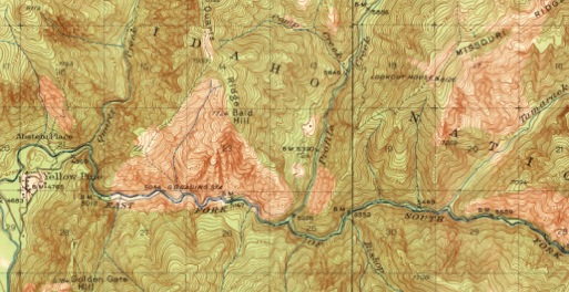
Yellow Pine topo map segment from 1943:

**CLICK HERE for the YPBHM's Outdoor Store - ATLASES & MAPS - on Amazon.com**


[YPBHM, Inc. is a participant in the Amazon Services LLC Associates Program, an affiliate advertising program designed to provide a means for sites to earn advertising fees by advertising and linking to amazon.com. YPBHM earns from qualifying purchases. Thank you for your support!]


USGS  topographic  maps

https://cida.usgs.gov/hqsp/apex/f?p=262:1:36614616756604:

This takes you to the search page – entering “Yellow Pine” in “Idaho” will take you to the Yellow Pine quadrangle maps.  See also other nearby towns such as Big Creek, Edwardsburg, Stibnite, Warm Lake, etc.  (These maps are in a range of dates, many not very old – but a few go back to the 1930s and 40s.)


https://www.natgeomaps.com/trail-maps/pdf-quads:

A new resource from National Geographic - free, easily printable USGS quads in .pdf format (4 segments per quadrangle), with an overview showing the area surrounding the full map as well.  Shading has even been added to make the contours easy to read.  Zoom in on U.S. map online to find your desired location, or use searchbox.  Download the quad to your browser or computer.  A wonderful resource!

OTHER  TOPOGRAPHIC  &  ROAD  MAPS


Idaho Road & Recreation Atlas (2022) – the whole shebang, in great detail, with highways and many landmarks noted; includes a GPS grid, field-checked for accuracy


Topographic Recreational Map of Idaho (2019) – 1″ = 12.5 miles, good overview of the state with 1000′ elevation contours, listings of smaller roads than highway maps, many camping and recreational facilities and other points of interest


https://www.historypin.org/map/#!/geo:44.966324,-115.491342/zoom:15/:


Here you can see a road map of Yellow Pine - and scoot to other areas roundabout.


BLM  GENERAL  LAND  OFFICE  RECORDS

https://www.glorecords.blm.gov/:


These include old federal land patents (including homestead patents), survey plats and field notes, and land status records.


U.S.  CENSUS  MAPS  OF  IDAHO

https://www.idgenweb.org/map-census.html:

See the boundaries for each US census taken in Idaho since 1850 (when Idaho was part of the Oregon Territory).


MISCELLANEOUS  HISTORICAL  IDAHO  MAPS

https://www.idgenweb.org/maps_places.html:

Here is a wonderful mishmash of links to Idaho maps through history (including ghost towns, pre-1900 Indian holdings, and a map of 1800s gold strikes).


https://alabamamaps.ua.edu/historicalmaps/us_states/idaho/index.html:
This is an extensive compendium of historic Idaho maps, from 1879 to 1948 (thank you, University of Alabama!).


MINES  IN  THE  WESTERN  UNITED  STATES

https://westernmininghistory.com/mines/:

An online resource showing all registered mines, from the USGS Mineral Resources Data System – click on Google map to zero in on area/mine desires, then click on “View mine details” for a data page.